We wanted to show our support for the Burrell Creek Riparian Project taking place adjacent to the 28 Mile Recreation Site, 44 km north of Grand Forks.
This project enhances the resilience of communities and ecosystems throughout the Boundary region by increasing the scope of knowledge, awareness and capacity in riparian and watershed health. The work includes the restoration on two sites along Burrell Creek (previously impacted by a wildfire) and the Kettle River (previously impacted by flooding and erosion) to kickstart a larger watershed-restoration project. The project will significantly reduce loss of land, reduce sediment which impacts downstream communities and water systems, and improve conditions during flood and drought events.
This project has three categories, and as of September 2024 all components have contractors working towards their success.
- Category 1. Rural Riparian Assessment and Ecosystem Services evaluation.
Consultants: Okanagan Nation Alliance (ONA) - Category 2. Community Engagement and Monitoring. Includes a 2-day forum (Spring 2025)
- Category 3. Riparian restoration at the Burrell Creek site.
Consultants: EcoLogic Consulting & Durand Landscaping


We’re excited to share the plant species that will be revitalizing the Burrell Creek Rural Riparian Project. Ready to dive in?
Moist Zone:
- – Bebb’s willow (Salix bebbiana)
- – chokecherry (Prunus virginiana)
- – Douglas maple (Acer glabrum)
- – mountain alder (Alnus incana tenuifolia)
- – Pacific (shining) willow (Salix lucida)
- – pussy willow (Salix discolour)
- – red-osier dogwood (Cornus sericea)
- – black cottonwood (Populus trichocarpa)
- – western red cedar (Thuja plicata)
- – water (river) birch (Betula occidentalis)
Mesic Zone:
- – Bebb’s willow (Salix bebbiana)
- – chokecherry (Prunus virginiana)
- – Douglas maple (Acer glabrum)
- – hawthorn (Crataegus douglasii)
- – Pacific (shining) willow (Salix lucida)
- – pussy willow (Salix discolour)
- – Saskatoon (Amelanchier alnifolia)
- – snowberry (Symphoricarpos albus)
- – Wood’s rose (Rosa woodsii)
- – black cottonwood (Populus trichocarpa)
- – Douglas fir (Pseudotsuga menziesii)
- – hybrid white spruce (Picea x glauca)
- – paper birch (Betula papyrifera)
- – western red cedar (Thuja plicata)
- – trembling aspen (Populus tremuloides)
Mesic to Dry Zone:
- – buffaloberry (Shepherdia canadensis)
- – hawthorn (Crataegus douglasii)
- – mock orange (Philadelphus lewisii)
- – Saskatoon (Amelanchier alnifolia)
- – snowberry (Symphoricarpos albus)
- – Wood’s rose (Rosa woodsii)
- – black cottonwood (Populus trichocarpa)
- – Douglas fir (Pseudotsuga menziesii)
- – paper birch (Betula papyrifera)
- – western red cedar (Thuja plicata)
- – trembling aspen (Populus tremuloides)
- – lodgepole pine (Pinus contorta)
- – Ponderosa pine (Pinus ponderosa)
Dry Zone:
- – buffaloberry (Shepherdia canadensis)
- – Oregon grape (Mahonia aquifolium)
- – Wood’s rose (Rosa woodsii)
- – Douglas fir (Pseudotsuga menziesii)
- – lodgepole pine (Pinus contorta)
- – Ponderosa pine (Pinus ponderosa)
- – trembling aspen (Populus tremuloides)
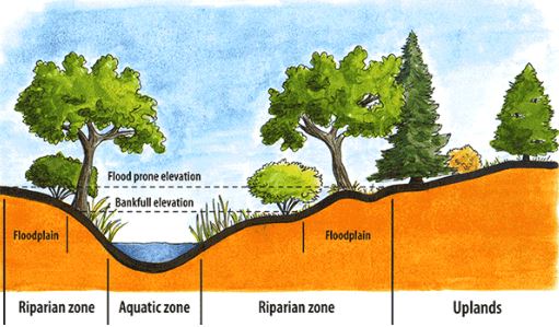
What is a riparian area?
A riparian area is the area of land adjacent to a body of water (ie: streams, creeks, lakes, wetlands, ponds, etc) that plays a crucial role in maintaining water quality, preventing erosion, and providing habitat. It forms a corridor between the land and a body of water, whether the water is flowing or standing. The overall area is made up of three zones: the aquatic zone, the riparian zone, and the upland zone. A healthy riparian area contains diverse plant species and both aquatic and terrestrial wildlife.

The aquatic zone is the water body itself, including the stream bed, banks, and any submerged vegetation. Key features of the aquatic zone include:
– Providing habitat for fish, invertebrates, amphibians, and reptiles
– Supporting aquatic plants like algae, aquatic grasses, and rooted plants
– Playing a vital role in water filtration and nutrient cycling
The riparian zone is the transitional area between the aquatic zone and the upland zone. Key features of the riparian zone include:
– Inclusion of wetlands, marshes, and swamps
– Providing habitat for a variety of wildlife (birds, mammals, and insects)
– Characterized by moisture-loving plants like willows, alders, and cottonwoods
– Helps with bank stability and the prevention of erosion
The upland zone is the higher and drier area that borders the riparian zone. Key features of the upland zone include:
– Can include forests, grasslands, and/or agricultural fields
– Less directly influenced by the water body, but still plays an important role in the overall ecosystem
– Can serve as a buffer that protects the riparian zone from disturbances
Why does this project exist?
Along waterways the loss of land from erosion, increased sedimentation and loss of habitat is a growing concern in the Boundary. As extreme weather events become the norm, this project aims to identify riparian areas throughout the Boundary that are at risk of future degradation.
What causes a riparian area to be ‘at risk’?
In general, an unhealthy riparian area is one with poor soil quality, little-to-no plant life, and/or no diversity in the plants and wildlife present:
– Poor soil composition in the riparian zone has a higher potential for erosion during high moisture events.
– A lack of both aquatic and terrestrial plant species is an indicator of an unhealthy riparian area. Trees, shrubs, and some grasses use their roots, water uptake ability, and mass to help stabilize the banks and waterways. They play a crucial role in preventing erosion

Why does it matter if a riparian area is at risk?
When a riparian area is lacking these fundamental building blocks (healthy soils, diverse vegetation and wildlife, etc), it holds the potential to cause downstream damage. High water events, such as heavy rain fall or flooding, can move large amounts of sediment downstream. The sediment is deposited in slower-moving areas like floodplains and river bends, forming gravel bars or islands. These formations can alter the flow of water, potentially causing erosion or flooding. Additionally, these new routes can reduce the water depth, leading to increased water temperatures during the summer months. This warmer water can harm fish, invertebrates, and amphibians. The increase of sediment in the water can water quality, hindering vegetative growth and reducing oxygen levels for fish. While a certain amount of sediment movement is necessary for a healthy ecosystem, excessive amounts can have detrimental effects.
What else?
Have you got a question that we missed? Feel free to reach out to bdrywaterwise@rdkb.com with your questions!
12,357 plants went into the ground at the Burrell Creek project site! That’s 10, 587 potted plants and plugs and an approximate 1,500 live stakes.
What’s the difference between a potted plant, plug, and live stake? I’m glad you asked. A potted plant is a plant that has been grown to a specific size and comes in a pot. It’s ready to go directly into the ground at its destination. The majority of potted plants used for this planting arrived in one-and-two gallon pots. Potted plants are also typically larger and more mature than a plug, which is a young plant in the early stages of growth. They are often grown in cells or trays and need to be transplanted either into a larger pot or into the ground to continue growing.
A live stake is a cutting from a mature plant that is then planted directly into the ground to grow a new plant. The goal is for the cutting to develop roots and grow to maturity. Depending on the cutting taken, a live stake is often quite large and can be used for a variety of restoration tools beyond the growth of a new plant, like bank stabilization, landscape changes, and wildlife habitat. For the Burrell Creek project, live stakes were taken from local areas that are regularly disturbed like gravel pits, road margins, and recently harvested forests. The cuttings were from cottonwood (Populus tichocarpa), willows (Salix scouleriana, S. lasiandra, S. discolor and S. bebbiana) and red-osier dogwood (Cornus sericea). The majority of planting was done on the same day that the materials were harvested.
Thank you
We are grateful to the UBCM Community Emergency Preparedness Fund (CEPF) Disaster Risk Reduction-Climate Adaptation (DRR-CA) for their support in this project.
Thank you RDKB Watershed Planner for providing the materials and information for this post. For more information, please visit Burrell Creek Riparian Project.